
The Labyrinths & Liontaurs Campaign Setting
The Known World of the Old Empire is vast: 3,500 miles (5,600 km) east to west, 6,000 miles (9,650 km) north to south. It ranges from ice-bound land and sea in the north to "equatorial" temperatures in the deep south, far exceeding those of the more mundane planet. Clicking on the map below brings you to a large-scale (3,500 x 6,000) version in which one pixel is a mile (about 1.6 km). Any point on the map can be located with a grid coordinate. Three squares of the grid are described in more detail below.
A future project may include a similar level of detail for every square of the Known World.
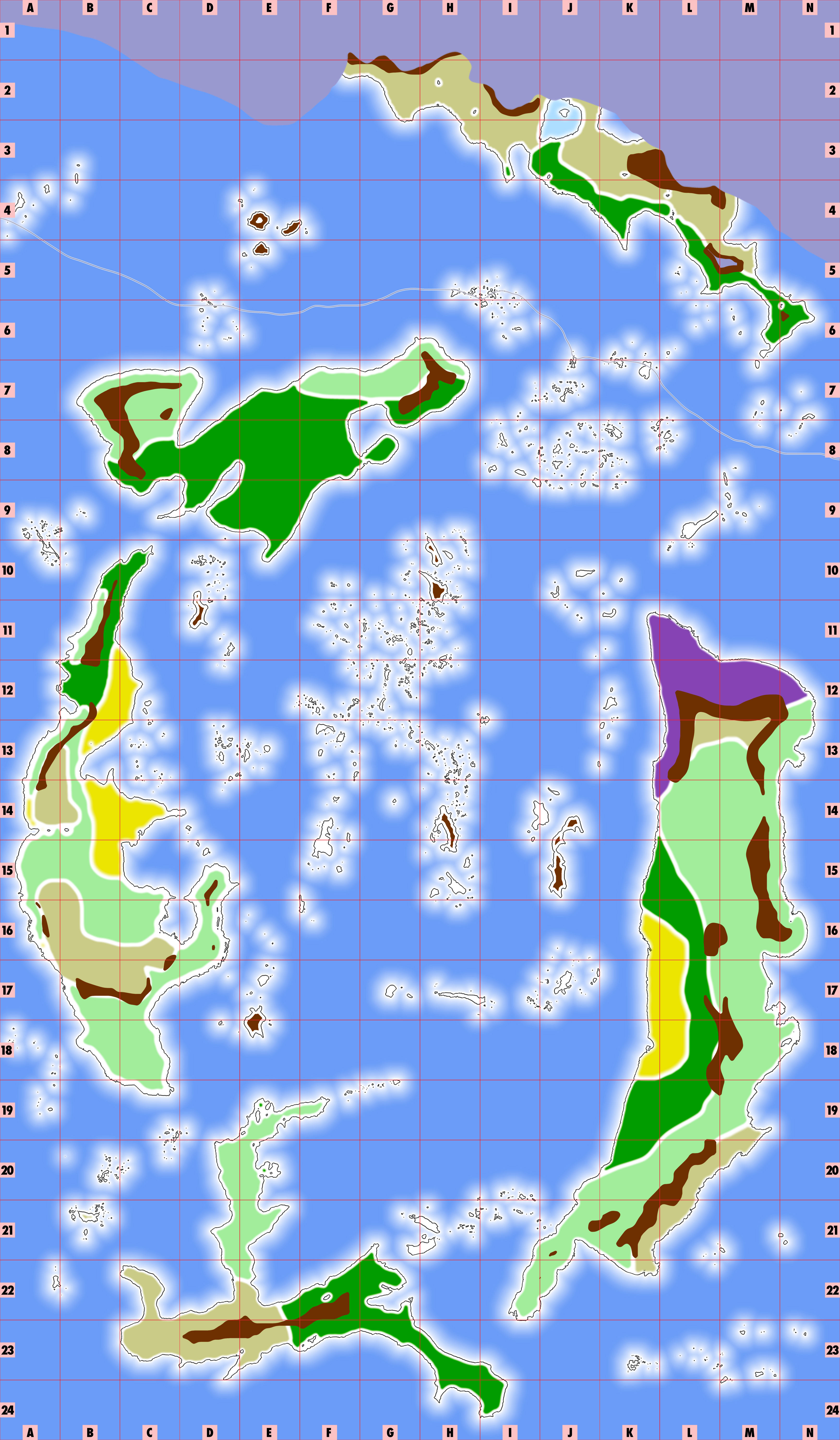
Key: For the map above, here is a guide to interpreting the colors and their meanings:
- Light violet in the far north is glaciers.
- The thin rule in the north shows the extent of the winter ice pack.
- Light tan represents badlands — tundra and peat bog in the north; dry shrublands and brush in the middle, and sandy deserts in the far south.
- Dark green is forest, taiga in the north, temperate woodlands and deciduous forest in the mid-latitudes, and jungle in the south.
- Dark brown is mountainous.
- Light green is grasslands, including savannah and prairie.
- Purple is swamp and marsh.
- Bright yellow is cultivated areas given over exclusively to civilized agriculture.
- The red grid forms squares 250 miles (400 km) on a side.
General Notes
The Known World is completely "known" by no one now living. The sphinx emperors knew it well, insofar as they ruled it for thousands of years. But the world has moved on, the time of the sphinxes has passed, and the courses and winds have changed, so that even the master loremasters do not know all.
On all maps given here, north is the direction towards the top of the map.
Wind Patterns
The center of the map, in the sunken land of the sphinxes, where only islands remain, is the site of a permanent hurricane (see below). Over the entire map, wind blows clockwise around the center. To describe the prevailing winds in your current area, locate the center of the map at G-H-12-13. Draw a line from your location to the center. Then draw a vector perpendicular to that line at your current location, pointing clockwise. That's the prevailing wind. The strength decreases as one moves away from the center.
Rain and Snow
Using the temperature and precipitation table for each square (see examples, below), you can tell the average number of days of precipitation in a 30-day month. If the mean daily minimum (°F) is less than 30, precipitation manifests as snow. If it is between 35-30°F, then there is a 50% chance it is snow. If the daily mean (°F) is 35 or less, snow accumulates; otherwise, it melts away within 1d4 days. To determine inches of snow, multiply inches of precipitation by six.
Calendar
The Known World uses the ancient dwarf calendar, who created it for the sphinxes eons ago: 12 months, four weeks per month, seven days per seek. Also, every fortnight, an extra day to honor the gods is added, in addition to the weeks. That makes for 30-day months. The twelve months still use the dwarvish names, although most races use the more common "J" sound rather than the original dwarvish "Z." The common translation is in parenthesis.
- Jangin (creek)
- Feb (arrow)
- Maram (soap)
- Apros (soothsayer)
- Mayal (cocoon)
- Juntar (anvil)
- Julash (wound)
- Augak (bee)
- Septal (spider)
- Octag (dell)
- Noval (bride)
- Decsor (entrance)
Each month name is linked to a foundational legend or myth about one of the ancient people of the Sphinx Empire: Elf, Kenku, Jannikin, Faun, Halfling, Dwarf, Orc, Kobold, Liontaur, Gnome, Centaur, and Sphinx.
Terrain Features
The main map does not show the presence of hills, rivers, settlements, or a range of other features. Most are too small. Hills are covered by other biome types: wooded hills are forest; meadowed hills are grasslands, etc. Hills can be assumed present surrounding mountains. On detailed maps (see below), hills are indicated by a darker flecked pattern.
Five Lands
The Known World includes five large lands, each roughly the same size as Greenland or the Arabian Peninsula. These five are at the edges of the Known World; clockwise from the top, they are:
Kaur'aus Revaura, an ice-locked and bitterly cold place of glaciers, tundra, and taiga. Humans arrived here first, though few live here now.
Je'oseko Lowki, the largest land, with many varied terrains. Now primarily filled with human kingdoms, who rule over gnomes and halflings and others, with liontaurs in the badlands and dry savannahs. Some ancient dwarfholds remain in the eastern mountains. prevailing winds from the north and west keep the climate cool.
Now Kiritona, a small, southerly, and extremely hot land. Only resilient dwarves have made permanent homes here. This is a place of sweltering jungles filled with dinosaurs — and sandy deserts filled with death.
Titaukausa, a pleasant land filled with every race, with cultivated and wild areas, home to the most advanced and sophisticated cultures since the fall of the sphinx empire. Winds and currents from the south and east make this a mild and pleasant land.
Tonitama Lowki, a cool land of cyprus and conifer forests, mountains, and some grasslands. This place is home to many elves.
These are the Five Lands as the liontaurs name them. Other cultures have their own names for these places, in their own tongues.
Detailed Notes
Each featured area below is a single grid square on the main map above. It describes an area 250 miles (400 km) on a side. It is further divided into a sub-grid with squares 25 miles (40 km) on a side.
Square G-22
This tropical bay is too extreme for most races of people. It is hot and wet all the time; temperatures over 100F (37C) are common, and a cool night is in the mid-80s. There is very little seasonal variation. The plant and animal life here is unique to this area. But hardy dwarves have made homes here. Non-dwarf visitors usually bring gear or a druid or a ranger to offer a magical solution to the dangerous heat — or stay underground in the day, emerging only at night.
Climate of Square G-22
| Month | Jan | Feb | Mar | Apr | May | Jun | Jul | Aug | Sep | Oct | Nov | Dec | Year |
|---|---|---|---|---|---|---|---|---|---|---|---|---|---|
| Mean daily maximum °F (°C) | 94.1 (34.5) |
93.7 (34.3) |
96.1 (35.6) |
97.3 (36.3) |
98.1 (36.7) |
97.5 (36.4) |
97.2 (36.2) |
97.7 (36.5) |
98.4 (36.9) |
98.4 (36.9) |
97.3 (36.3) |
95.9 (35.5) |
96.8 (36.0) |
| Daily mean °F (°C) | 87.8 (31.0) |
87.4 (30.8) |
88.7 (31.5) |
89.4 (31.9) |
90.0 (32.2) |
89.4 (31.9) |
89.1 (31.7) |
89.2 (31.8) |
89.8 (32.1) |
90.1 (32.3) |
89.4 (31.9) |
88.7 (31.5) |
89.1 (31.7) |
| Mean daily minimum °F (°C) | 83.7 (28.7) |
83.7 (28.7) |
84.2 (29.0) |
84.4 (29.1) |
84.7 (29.3) |
84.2 (29.0) |
83.8 (28.8) |
83.8 (28.8) |
84.2 (29.0) |
84.4 (29.1) |
84.4 (29.1) |
84.2 (29.0) |
84.2 (29.0) |
| Average precipitation inches (mm) | 16.17 (410.6) |
16.52 (419.5) |
9.11 (231.4) |
7.11 (180.5) |
4.47 (113.5) |
3.48 (88.4) |
3.37 (85.5) |
2.23 (56.7) |
2.64 (67.1) |
4.86 (123.4) |
5.84 (148.3) |
7.94 (201.6) |
83.74 (2,126.5) |
| Average precipitation days (≥ 1.0 mm) | 19.3 | 19.7 | 15.5 | 12.7 | 9.0 | 6.8 | 5.3 | 3.6 | 4.4 | 8.1 | 11.4 | 14.1 | 129.9 |
| Mean monthly sunshine hours | 139.5 | 138.3 | 189.1 | 216.0 | 220.1 | 219.0 | 229.4 | 235.6 | 225.0 | 207.7 | 180.0 | 148.8 | 2,348.5 |
Map of Square G-22
Notes of Interest
Flora and Fauna: The hot temperatures and plentiful rainfall foster plants and animals unique in the Known World. Giant insects, primates, elephants, hippos, and huge snakes vie for space with a range of dinosaurs. Plant life features cycads, palms, pandanus, and enormous vines. Giant ferns are common in the hills and uplands, with mangrove swamps along the coasts.
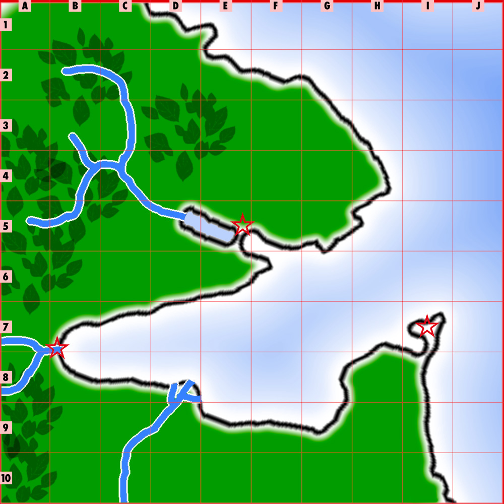
This square is notable for its sheltered bay, named Cattenebal, into which rivers and streams flow from the mountains to the west.
Largest Settlement: The dwarf town of Ast Adagshorast (located at B-7 on the subgrid) is the most southerly harbor in the Known World. It is mostly populated by the resilient race of dwarves, because only they are unaffected by the climate — other races quickly succumb to heat exhaustion and tropical agues if they visit at all. Situated at a river delta, the city lives on trade with the mountainous dwarvenholds to the east and merchants visiting from across the sea. Unlike traditional dwarven holdfasts, Ast Adagshorast is only partly underground. Here, dwarf fishers work in the surf, hunters seek megafauna, and gatherers scour the jungle for breadfruit, mangoes, coconuts, and bananas, among many other useful local plants. A wall surrounds the entire area, not so much to resist invaders, but to fence out the dinosaurs. With pick and shovel, dwarves have also dug into the sand, clay, and stone above the aquifer to create traditional underground farms, sleeping chambers, meeting areas, temples, and more. River barges carry goods for commerce inland, and the sheltered bay is a fine natural harbor for ocean-going vessels.
- Alignment and Type: Lawful Good Small City
- Corruption +1; Crime +0; Economy +3; Law +3; Lore +1; Society +2
- Qualities prosperous, pious, insular, strategic location
- Danger +5
- Government autocracy, with an independent judiciary
- Population 20,000 (18,000 dwarves; 1,000 gnomes; 1,000 other)
- Notable NPCs
King Urist (LG male dwarf fighter/aristocrat)
High Judge Urist (LG female dwarf loremaster)
Aarni Green, Master of Gems and Coin (LN male gnome expert)- Market: Base Value 4,800 gp; Purchase Limit 30,000 gp; Spellcasting (divine) 9th; Magic Items 4d4
Other Notable Settlements: In the hills on the north side of the bay, at E-5, where a river dug through cliffs to reach the sea, a xenophobic community of dwarves has dammed the river and created a lake. Their community, named Alathsikel, is almost entirely underground, aside from a trade depot, the only place outsiders are welcome. Their purpose in damming the river is unknown.
At the entrance to the bay, at I-7, on a sandy peninsula, a community of dwarves, named Zasit, has tapped underground wells of heat to produce elaborate glassworks. They have used strengthened glass bricks to wall off the peninsula from dangers, so the only access is by boat. The glassworks here is among the best in the Known World; the dwarves have mastered the art of making expensive, break-resistant glass objects (treat as silver), including their local coinage, weapons, and tools!
Intersection G-H-12-13
The very center of the Known World is a place with a deep history. In the times before the Universal System, the Five Lands were actually numbered Six, and the sixth, mightier than the others, was the home of the sphinxes. Nowadays, even those who know them do not speak or write the ancient names of the Sixth Land or the sphinx empire to which the land was the refuge and home. In the days of their pride, the sphinxes aspired to the power of gods, creating the liontaur race. They stood in their temples before the other races of people and demanded worship. For their hubris, the gods sank the Sixth Land, destroyed every sphinx temple, and let loose the race of orcs to punish the sphinxes. Alas, the orcs warred too well, and every sphinx was murdered. Of the Sixth Land, only islands remain. At the very center, at the site of the highest temple, the gods struck hardest. To this day, a permanent hurricane and a powerful whirlpool mark the place of their wrath, a lesson and warning to those who seek to climb too high.
Climate of Intersection G-H-12-13
| Month | Jan | Feb | Mar | Apr | May | Jun | Jul | Aug | Sep | Oct | Nov | Dec | Year |
|---|---|---|---|---|---|---|---|---|---|---|---|---|---|
| Mean daily maximum °F (°C) | 57.8 (14.3) |
60.4 (15.8) |
62.1 (16.7) |
63.0 (17.2) |
64.1 (17.8) |
66.5 (19.2) |
66.3 (19.1) |
67.9 (19.9) |
70.2 (21.2) |
69.8 (21.0) |
63.7 (17.6) |
57.9 (14.4) |
64.1 (17.8) |
| Daily mean °F (°C) | 52.2 (11.2) |
54.2 (12.3) |
55.5 (13.1) |
56.4 (13.6) |
57.8 (14.3) |
59.7 (15.4) |
60.3 (15.7) |
61.7 (16.5) |
62.9 (17.2) |
62.1 (16.7) |
57.2 (14.0) |
52.5 (11.4) |
57.7 (14.3) |
| Mean daily minimum °F (°C) | 46.6 (8.1) |
47.9 (8.8) |
48.9 (9.4) |
49.7 (9.8) |
51.4 (10.8) |
53.0 (11.7) |
54.4 (12.4) |
55.5 (13.1) |
55.6 (13.1) |
54.4 (12.4) |
50.7 (10.4) |
47.0 (8.3) |
51.3 (10.7) |
| Average precipitation mm (inches) | 569.8 (22.43) |
487.3 (19.19) |
538.8 (21.21) |
652.9 (25.70) |
785.1 (30.91) |
774.8 (30.50) |
851.7 (33.53) |
867.4 (34.15) |
698.4 (27.50) |
588.4 (23.17) |
662.3 (26.07) |
680.0 (26.77) |
8,156.9 (321.14) |
| Average precipitation days (≥ 1.0 mm) | 22.2 | 19.1 | 21.3 | 24.0 | 25.1 | 24.0 | 25.1 | 26.3 | 25.2 | 24.5 | 24.6 | 25.5 | 286.9 |
| Mean monthly sunshine hours | 90.5 | 83.4 | 85.6 | 92.9 | 112.5 | 114.0 | 135.1 | 132.7 | 112.7 | 116.7 | 112.2 | 88.1 | 1,276.4 |
Note that the table above notwithstanding, at the very center of the intersection, the rains always fall, and the skies are never clear, and the winds ever blow.
Map of Intersection G-H-12-13
Notes of Interest
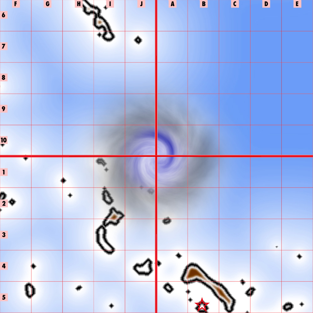
Climate and Creatures: The hurricane at the center of the Known World is permanent, although it does wax and wane. It rotates clockwise, and all the winds of the world do the same, circling the center. Within 25 miles of the center, use the mechanics for a powerful storm. Within 50 miles, treat the wind strength as windstorm-level; within 75 miles, as severe-level; and within 100 miles, as strong-level, all the time, without ceasing.
At the center of the eye of the hurricane, the airs may be calm, but the waters are not. A huge whirlpool, miles across, swirls down at the very center of the world. No adventurer or scholar-explorer has entered the whirlpool and returned.
The islands within this area, up to 100 miles from the center, are simply lifeless scoured rock. Some say that there may be ruins or labyrinths with great treasures on these islands — but these are rumors only.
The outermost islands on this map are mostly beach and sand, with plants and trees clinging hard, bent over in the force of the wind. Creatures are crawlers and swimmers, because any flying creature is blown swiftly away.
Largest Settlement: There are two notable islands at subgrid B-C-4-5 of Square H-13. As the halflings name them, these are Great Echo Island and Little Echo Island. The big island, with its stone highlands and cliffs, gives a measure of shelter to the small island. The Temple of Lost Lore is located on Little Echo. Administered by halfling clerics devoted to E'aff'ah and Ee'tal, the Temple is an academy devoted to the study of the lost empire and the history of the sphinxes. The Temple attracts academics and scholars of any race and nation. Most food is imported, and the community is often isolated when the hurricane waxes.
- Alignment and Type: Neutral Good Small Town
- Corruption -2; Crime -2; Economy +0; Law -2; Lore +3; Society +3
- Qualities academic, holy site
- Danger +0
- Government democracy, all academics and priests can vote
- Population 5,000 (2,000 halflings; 3,000 other)
- Notable NPCs
Prelate Tom Shellseeker (NG male halfling cleric)
Academician Radril Stormchased (N female elf chronicler)- Market: Base Value 1,000 gp; Purchase Limit 5,000 gp; Spellcasting (divine & arcane) 7th; Magic Items 3d4
Other Notable Settlements: Mostly people avoid the Center, at least this close! It is too easy to get swept up in the hurricane and to crash against the rocks and remnants of the old drowned empire. There are a few gnomish fishing villages on the edges: at F-5 of Square G-13, and at H-6 of Square G-12.
Square L-14
This stretch of prairie coast is split by the River Magenta, home to the Free City of Magenta. In the northeast sits the Ribble Swamp; in the southeast, the Celebrin Wood, known for its silver-leaved echui trees, known to awaken into ents from time to time. Most of the prairie is populated by liontaur tribes, who have learned through hard lessons that to be fiercely territorial and well-armed is the only choice when slavers raid from the south or from the shore.
Climate of Square L-14
| Month | Jan | Feb | Mar | Apr | May | Jun | Jul | Aug | Sep | Oct | Nov | Dec | Year |
|---|---|---|---|---|---|---|---|---|---|---|---|---|---|
| Mean daily maximum °F (°C) | 32.4 (0.2) |
35.0 (1.7) |
42.3 (5.7) |
53.8 (12.1) |
64.2 (17.9) |
73.6 (23.1) |
79.5 (26.4) |
78.7 (25.9) |
71.1 (21.7) |
59.5 (15.3) |
48.4 (9.1) |
38.3 (3.5) |
56.4 (13.6) |
| Daily mean °F (°C) | 24.0 (−4.4) |
26.2 (−3.2) |
34.1 (1.2) |
44.6 (7.0) |
54.9 (12.7) |
64.3 (17.9) |
70.4 (21.3) |
69.2 (20.7) |
61.6 (16.4) |
50.3 (10.2) |
40.0 (4.4) |
30.3 (−0.9) |
47.5 (8.6) |
| Mean daily minimum °F (°C) | 15.6 (−9.1) |
17.3 (−8.2) |
26.0 (−3.3) |
35.4 (1.9) |
45.5 (7.5) |
55.0 (12.8) |
61.2 (16.2) |
59.7 (15.4) |
52.1 (11.2) |
41.0 (5.0) |
31.7 (−0.2) |
22.4 (−5.3) |
38.6 (3.7) |
| Average precipitation inches (mm) | 3.50 (89) |
3.54 (90) |
4.08 (104) |
4.41 (112) |
3.67 (93) |
4.15 (105) |
3.43 (87) |
3.57 (91) |
3.77 (96) |
5.25 (133) |
4.25 (108) |
4.50 (114) |
48.12 (1,222) |
| Average precipitation days (≥ 0.01 in) | 11.2 | 10.2 | 11.3 | 11.1 | 12.5 | 11.7 | 10.8 | 9.4 | 9.3 | 10.9 | 10.7 | 12.3 | 131.4 |
| Mean monthly sunshine hours | 164.8 | 172.8 | 205.2 | 213.5 | 243.2 | 259.1 | 282.2 | 267.6 | 229.1 | 195.7 | 138.7 | 140.9 | 2,512.8 |
Map of Square L-14
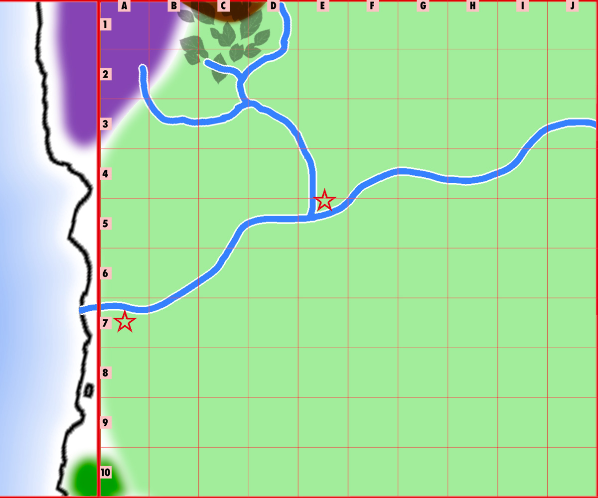
The map above includes a sliver of Square K-14 to provide coastal context.
Notes of Interest
Flora and Fauna: The wide prairies of this land are home to a remarkable range of magical beasts — in the north, winter wolves come down from the mountains on the prowl; ankhegs and land sharks swim through the grassland earth like water; chimera hunt from the skies; in early spring, kraken swim up the river to spawn before returning to the sea; unicorns range up from the southern woods — many dangerous monsters roam! The grasslands are wide and wild, and in the winter are often layered under snow.
Geography: The River Magenta meanders through the land, wide and deep, from its high sources to the east. It is joined at subsquare E-5 by the Onget River, which comes down from dwarven mountains to the north, and from the swamp to the northwest. Where the Onget meets the Magenta is a permanent town of liontaurs, called Frahir. The Magenta then runs more swiftly down to the Free City, situated 25 miles from the coast, the better to be protected from hurricanes and winter blizzards.
Largest Settlement: The Free City of Magenta is the richest, most sophisticated, most cosmopolitan city in the Known World. Founded by jeweler gnomes, its Adventurers' Guild is a powerful force in the polis, focused as it is on hunting magical beasts and harvesting the magical gems found in their guts. But the life blood of Magenta is trade. Hides, meat, furs, and crafts from the interior, beautiful and useful objects of white wood from the southeast, masterfully worked metal from the north, and spices from over the sea are all available in Magenta.
With visitors and inhabitants from every race and nation, the Free City is a bastion of tolerance and civilization. Even humans are welcome, albeit sceptically. A notable feature of the city is that slavery is outlawed; any slave setting foot in the city is automatically free. This has made them a bitter enemy to the human slaver nations to the south.
As a metropolis originally created by gnomes, the heart of the Old Town district is made for small folk, and it is a warren of narow streets and houses with tiny doors. But outside this neighborhood, there are accommodations for every kind. Nonetheless, "Magenta" remains a very common surname, following the gnome tradition.
The city is ruled by the Council of Guildmasters, of whom the Adventurers' Guild, the Jewelers' Guild, the Merchants' Guild, the Minstrel's Guild, the Assassin's Guild, and the Navigator's Guild are foremost. There is a significant difference in class and rank between those who are guild members and commoners who belong to no guild. Note that no nobility nor order of aristocracy is recognized in the Free City of Magenta. The city has no standing army, but relies on adventurers and assassins for its security — not to mention the city's alliance with local liontaur clans.
The city boasts a huge colosseum, known for its games and entertainments, and especially for its magically enhanced musical and dramatic performances. Every seat is enchanted so that the watcher can see and hear perfectly, from a solist softly singing to a battle waged by members of the Guild of Gladiators.
- Alignment and Type: Neutral Good Metropolis
- Corruption +3; Crime +5; Economy +9; Law +4; Lore +2; Society +10
- Qualities Prosperous, Strategic Location, Tourist Attraction; Freedom-Loving (econ +1, corruption -1), Tolerant (society +2, danger -5), Cosmopolitan (+1 crime, +1 economy)
- Danger +5
- Government council ("The Council of Guildmasters")
- Population 33,000 (10,000 gnomes, 6,000 elves, 4,000 dwarves, 3,000 halflings, 3,000 humans (and humelves and wildlings), 3,000 liontaurs, 2,000 grippli, 1,000 kobold, 500 kenku, 500 fauns)
- Notable NPCs
Guildmaster of Jewelers Brom Thymol Blue (NG male gnome expert)
Adventurers' Guildmaster Vauhwyt (LG female liontaur ranger)
Guildmaster of Minstrels Krystal Magenta (N female gnome bard)- Market: Base Value 22,000 gp; Purchase Limit 100,000 gp; Spellcasting 8th; Magic Items all minor
Other Notable Settlements: in subsquare E-5, where two rivers meet, is the permanent liontaur town of Frahir. This is a religious center as well as the meeting place of all the tribes during the annual Taurmoot, and it is where chiefs gather to plan defences for war and invasion. It is also a trading post, a fair, a center of the arts, and a place to seek mates.